

Atlantic hurricanes are strong storms that start in the ocean and have winds of at least 120 kilometres an hour. In the Northern Hemisphere hurricanes usually occur between mid-August to late October. During these times, oceans have warmer water, which is what a hurricane needs to form.
Hurricanes begin when a line of rain showers and weak thunderstorms circle around an area of low air pressure over the ocean. If the water is at least 26°C, a hurricane might form. The low air pressure causes the hot, humid air to rise in a spiral shape. As that warm air rises, it releases heat, cools down, and condenses into bands of clouds and storms. The low-pressure area continues to suck up hot, moist air, and the spiral gets stronger and faster.
 When winds reach 63 kilometres an hour, the tropical depression becomes a tropical storm. When winds reach 120 kilometres an hour, it's officially a hurricane.
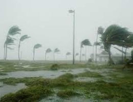
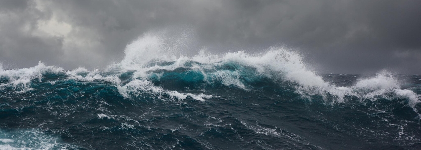
When the hurricane moves over cooler water or hits land, it loses the warm water that fuels it and begins to weaken. But dangerous winds can still cause damage, and storm surges (when a strong storm pushes ocean water ashore) can flood coastal areas. Heavy rains and floods can continue far inland.
Hurricanes are classified both by wind speed and the amount of damage that scientists predict the storm will cause when it reaches land. For example, a Category 1 storm has wind speeds of 120 to 153 km/h and will probably damage some homes and cause power outages. But a Category 5 hurricane is considered a powerful, destructive storm. These storms have winds of 251 km/h or more and will likely cause so much damage that homes are abandoned and will need months to clean up. Play the video below to see a dramatic illustration of the damages caused by increasing wind speeds.
University Corporation for Atmospheric Research
This image is freely available for media & nonprofit use
Assigned hurricane names alternate between female and male names, and repeat. However, the names of a few of the historically most damaging tornadoes, such as Katrina and Andrew, have been removed from the list. And Q, U, X, Y, or Z are not used.
In the future, scientists don't expect to see more hurricanes, but they do expect more powerful ones. That's because hurricanes get bigger more quickly in warmer water. Climate change is causing ocean temperatures to rise, and scientists predict that future hurricanes will come with more rain and damge, and last longer.
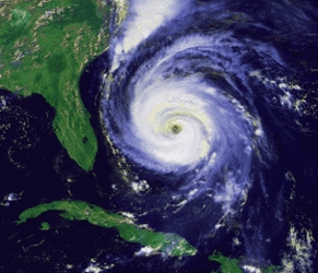
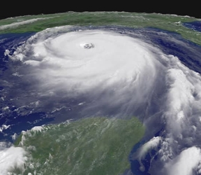
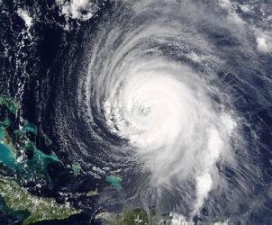 Usually hurricanes are about 500 km wide, but can vary considerably in size. The eye at a hurricane's center is a calm, clear area about 30-65 km across. The 'eyewall' surrounding that eye is made up of dense clouds that have the highest winds in the storm. The storm's outer rain areas, often with hurricane-force winds, are made up of dense rows of thunderstorms ranging from a few kilometres to tens of kilometres wide and 80 to 500 kilometres long. The right side of a hurricane is often the most dangerous in terms of storm surge, winds, and tornadoes.
A hurricane's speed and path are very difficult to predict.
Some powerful Atlantic hurricanes, by year, with wind speed
- Florida Keys hurricane 1935 - 296 km/h
An unnamed storm that tore up the Florida Keys over Labor Day in 1935 is still considered one of the most intense storms in US history, based on wind speeds and pressure. The wind was so powerful it knocked a train off the rails as it was delivering emergency supplies.
- Hurricane Carla 1961 - 280 km/h
Hurricane Carla hit Texas as a category 4 storm in 1961, causing $2.36 billion worth of damage. Its strong winds and storm surge had devastating consequences.
- Hurricane Camille 1969 - 280 km/h
Hurricane Camille formed in the Gulf of Mexico and hit Mississippi as a Category 5 storm. Camille caused more than 256 deaths and is considered one of the most intense hurricanes to hit the US, based on its pressure, which was measured at 900 millibars. (The more intense a hurricane is, the lower its pressure. At sea level, standard air pressure in millibars is 1013.)
- Hurricane Allen 1980 - 305 km/h
With maximum winds of 305 km/h, Hurricane Allen holds the record as the storm with the highest wind speeds in the Gulf of Mexico. The storm hit along the Mexico-US border in Texas, traveling west. Allen had the highest sustained wind speeds ever recorded in the Western Hemisphere until Hurricane Patricia formed in the Pacific in 2015 with 344 km/h winds.
- Hurricane Gilbert 1988 - 296 km/h
Hurricane Gilbert ripped up the Caribbean and the Gulf of Mexico in 1988 with 296 km/h winds and 888 millibars of pressure, the second-lowest recorded in the Atlantic Ocean. The storm left destruction in Jamaica and Mexico before moving north through San Antonio.
- Hurricane Andrew 1992 - 280 km/h
Hurricane Andrew tore through Florida with 280 km/h winds, leaving millions without power and many neighborhoods completely destroyed. The response was so problematic that it led to major changes within the Federal Emergency Management Agency (FEMA).
- Hurricane Mitch 1998 - 288 km/h
Hurricane Mitch hit Central America with 288 km/h winds in 1998. The storm led to disastrous flooding in Honduras.
- Hurricane Katrina 2005 - 280 km/h
Katrina was the third deadliest hurricane in US history, with more than 1,200 deaths. It caused $108 billion in damage, destroyed the levees around New Orleans, and became the costliest hurricane the country has ever seen.
- Hurricane Rita 2005 - 288 km/h
Just a few weeks after Katrina devastated New Orleans and other parts of Louisiana, Hurricane Rita formed. The storm brought heavy rainfall to the state again, and hit Texas as well, causing $12 billion in damages. It's often referred to as the 'forgotten storm' of the horrific 2005 season.
- Hurricane Wilma 2005 - 296 km/h
Hurricane Wilma broke records at the time as the most intense hurricane ever to hit the Atlantic Ocean. It had the lowest central pressure of any hurricane in the Atlantic basin, with an estimated pressure of 882 millibars. The Category 3 storm was especially damaging to Mexico, Cuba, and Florida. Currently, Hurricane Wilma is the strongest Atlantic hurricane ever recorded, after reaching an intensity of 882 mbar in October 2005; at the time, this also made Wilma the strongest tropical cyclone worldwide outside of the West Pacific.
- Hurricane Irma 2017 - 296 km/h
Hurricane Irma approached Puerto Rico and Florida with maximum winds of 296 km/h. It was part of a destructive 2017 hurricane season, and set a record for maintaining an intensity of 296 km/h for 37 hours.
- Hurricane Dorian 2019 - 295 km/h
Hurricane Dorian was an extremely powerful and catastrophic Category 5 Atlantic hurricane, which became the most intense tropical cyclone on record to strike the Bahamas, and tied for strongest landfall in the Atlantic basin. It is also regarded as the worst natural disaster in the Bahamas' recorded history.
Resources
HTML, graphics & design by Bill Willis 2023
|