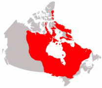
 The Canadian Shield is a large geographic area in eastern and central Canada composed of bare rock dating to the Precambrian era (between 4.5 billion and 540 million years ago). It is also called the Precambrian Shield, or Laurentian Shield. In total it covers approximately 8 million square kilometers. The Canadian Shield is made up of some of the planet's
oldest rock, largely granite and gneiss. The Canadian Shield is a large geographic area in eastern and central Canada composed of bare rock dating to the Precambrian era (between 4.5 billion and 540 million years ago). It is also called the Precambrian Shield, or Laurentian Shield. In total it covers approximately 8 million square kilometers. The Canadian Shield is made up of some of the planet's
oldest rock, largely granite and gneiss.
The shield is mostly thin soil lying on top of bedrock, with many bare outcrops and thousands of lakes. This was caused during the last ice age, when glaciers covered the area and scraped the rock clean as they moved. A few million years of advancing and retreating glaciers have actually carried pieces of the shield into southern Ontario and the northern United States 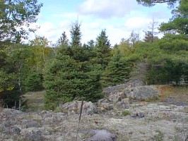 The shield was originally a region of very large mountains and some volcanic activity, but over the millennia the area was eroded. Mountains have deep 'roots', and float on the denser mantle below. As mountains erode, their roots rise, and are slowly eroded as well. The rocks that now form the surface of the Canadian Shield were once far below the earth's surface. The high pressures and temperatures at those depths created many forms of minerals in the rocks. Since the end of the last ice age - 15,000 years ago in southern Ontario, but only about 6,000 years ago in northern Quebec - the land has become covered with a thick boreal forest of coniferous trees. Today, much of the Canadian Shield is home to mining industries of various sorts, as well as logging and other forestry-related industries. As you drive through northern Ontario, the Canadian Shield bedrock is clearly visible, especially in areas where the highway is being widened. Unlike in other regions where highway construction involves merely moving around a lot of dirt, in northern Ontario, making a road is a major undertaking! 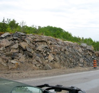
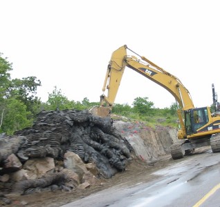
The hills are solid rock, and must be blasted literally to pieces with dynamite. This is not so easy when vehicles are passing by on the highway; construction teams spread huge 'blankets' of old tires over the rock face to be blasted, and traffic is stopped until after detonation. Then heavy equipment clears away the pieces of rock, which are used to fill in low areas. 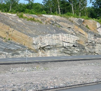
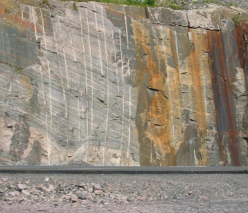 In the two pictures above, you can see how far down the surface rock had to be removed to make a level road. Clearly visible are the layers in the rock, layers that were folded in gentle curves millions of years ago by the intense heat and pressure deep underground. Also visible in these pictures are many vertical 'white stripes' in the rock that are actually the drill holes where dynamite was inserted to blast apart the rock. 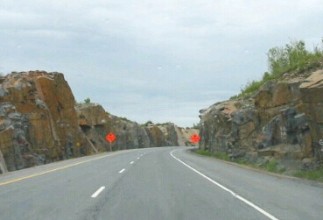
At the right you can see the final result ... a highway that cuts right through the top layers of the rock of the Canadian Shield. One unfortunate side-effect of building highways here is that the steep rock walls that the highway passes through don't allow for errors on the drivers' part ... if you go off the road at high speed, your accident will likely be fatal. The Canadian Shield stretches over much of Northern Ontario and Michigan. Despite being separated by Lake Superior, these two regions share many geological features, one of which is plentiful deposits of iron ore. The iron (actually iron oxide, or rust) in the exposed rocks colours them red in some regions. There is actually a town in Northern Ontario called Red Rock. The iron oxide in the rock also gets into the mix they use in both regions for asphalt, giving the highways in both places a red tint. The rock in northern Minnesota and Michigan, across Lake Superior, is the same.  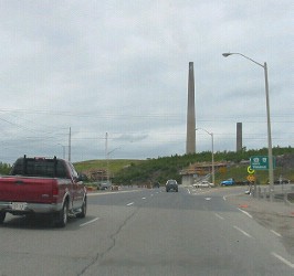 The largest Ontario city on the Canadian Shield is Sudbury. Sudbury is named after a town in England. Located just north of the Great Lakes, about 4 hours north of Toronto, the region is thought to be the site of an asteroid impact with the earth many millions of years ago, as the underlying rock contains a vast deposit of minerals. The small town of Copper Cliff (now a part of Greater Sudbury) is the location of a huge complex of mines, smelters, and refineries, which since the late 1800's have been in place to extract this mineral wealth from the ground. The area produces nickel, copper, silver, iron ore, and various other valuable minerals. I grew up there. When the area was originally settled in the late 19th century, most of the timber was cut down, a lot of it to fuel the giant smelters which melted the rock to allow the minerals to be removed. The fumes from these operations (which included the noxious and toxic sulphur dioxide) also served to kill off much of the remaining vegetation. For most of the 1900's the region around Copper Cliff was a barren wasteland of exposed rock, as well as slag (worthless rock) left over from smelting operations and dumped wherever it was convenient. Nevertheless, the region prospered, as there was a large world-wide demand for the metals being produced, particularly nickel. The city of Greater Sudbury became one of the largest cities in northern Ontario. Huge smokestacks, and later a single 'superstack', allowed much of the sulphur dioxide to blow somewhere else*, leaving the air reasonably clean, and allowing vegetation to return. In recent decades, both the city and the principal mining company have undertaken a reclamation project, in which topsoil, grass and trees have been put in place over the rock and slag dumps. 
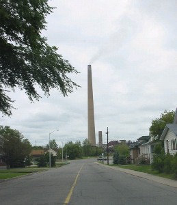 I visited Sudbury and Copper Cliff during the summer of 2004 to see how it had changed since I was growing up there in the 50's and 60's. Despite the fact that the region's mines and smelters are no longer the biggest or most productive in the world, the region has definitely continued to prosper. The greening program has created a startling transformation ... there is grass and vegetation everywhere! The picture at the left just above shows what was once a huge slag dump area, barren of everything except crushed rock. it is now (at least, as seen from the highway) a pleasant vista of green rolling hills and trees. The picture at the right is a typical small street in Copper Cliff, with the superstack visible in the background. Since this stack went into operation, the town seldom has to put up with the clouds of sulphur dioxide that used to make just breathing an unpleasant experience. There are more trees than there ever were before. * The superstack, constructed in the late 1960's, did indeed help clear Sudbury's air. The idea was that releasing the pollutants into the air high up would allow them to be dispersed widely, so that when they fell to earth they would be relatively harmless. In fact what actually happened was that the pollutants from the stack traveled south and fell into the lakes of central and southern Ontario, helping to cause widespread acidity in the lakes ... most of which are now dead. |