 Continental drift was one of the earliest ways geologists thought continents moved over time. Today, the theory of continental drift has been replaced by the science of plate tectonics. 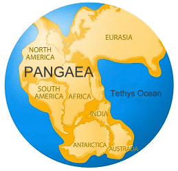 The theory of continental drift was proposed by scientist Alfred Wegener in the early 20th century. He suggested that the continental landmasses were 'drifting' across the Earth, sometimes plowing through oceans and into each other. He called this movement 'continental drift'. Wegener was convinced that all of Earth’s continents were once part of an enormous, single landmass called Pangaea.
His evidence was quite compelling. He noticed that fossils of the ancient reptile mesosaurus are only found in southern Africa and South America. As a small freshwater reptile, it could not have swum the Atlantic Ocean. Wegener also studied plant fossils in the frigid north of Norway. These fossils were of tropical plants, which are adapted to a much warmer, more humid environment. The presence of these fossils suggests Svalbard once had a tropical climate. Wegener also studied the layers of different rocks and mountain ranges. The east coast of South America and the west coast of Africa seem to fit together like pieces of a jigsaw puzzle, and their rock layers fit together just as clearly. Wegener also discovered that the Appalachian Mountains of the eastern United States were geologically related to the Caledonian Mountains of Scotland. According to Wegener's theory, Pangaea existed about 240 million years ago. By about 200 million years ago, this supercontinent began breaking up. Over millions of years, Pangaea separated into pieces that moved away from one another. These pieces slowly assumed their positions as the continents we know today. However, many scientists did not accept Wegener's theory of continental drift. One of the elements missing in his theory was the mechanism for how it works. What caused the continents to drift? No one knew. It wasn't until advances in geology and the study of the earth's mantle and core provided the explanation, and Wegener was proved correct. Today, we know that the continents rest on massive slabs of rock called tectonic plates. The plates are always moving and interacting in a process called plate tectonics, powered by convection currents in the molten mantle below. The theory of plate tectonics revolutionized earth sciences by explaining how the movement of geologic plates causes mountain building, geologic faults, volcanoes, and earthquakes. The continents are still moving today. Some of the most dynamic sites of tectonic activity are seafloor spreading zones and giant rift valleys. Sea Floor Spreading 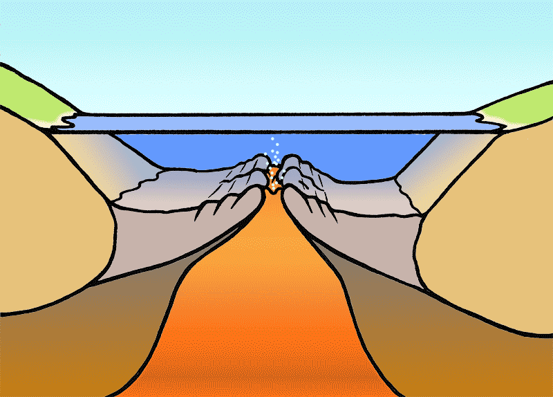 Molten rock rises from within the Earth and adds new seafloor (oceanic crust) to the edges of the old crust. Seafloor spreading is most noticeable along giant underwater mountain ranges known as mid-ocean ridges. As the seafloor grows wider, the continents on opposite sides of the ridge move away from each other. The North American and Eurasian tectonic plates, for example, are separated by the Mid-Atlantic Ridge. The two continents are moving away from each other at the rate of about 2.5 centimeters per year.
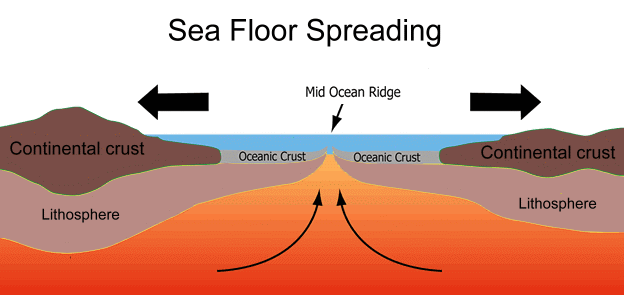 Rift Valleys  Rift valleys are sites where a continental landmass is ripping itself apart. Africa, for example, will eventually split along the Great Rift Valley system. The Great Rift Valley is a series of connected trenches, approximately 7,000 kilometres in total length, that runs from Lebanon in Asia to Mozambique in Southeast Africa. It is caused by two plates moving in opposite directions, causing a fracture of the crust. What is now a single continent will eventually become two -- one on the African plate and the other on the smaller Somali plate.
 Subduction 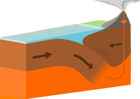 Subduction occurs when an oceanic plate runs into a continental plate and slides beneath it. Subduction zones, since they involve oceanic plates, are known for earthquakes that produce tsunamis, and are often responsible for volcanoes too.
 For example, where the Juan de Fuca plate is sliding beneath the North American plate, the subduction zone is largely responsible for the Cascade Volcanic Range, as well as significant earthquake and tsunami hazard for the Pacific Northwest. 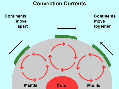 In plate tectonics, Earth’s outermost layer, or lithosphere -- made up of the crust and upper mantle -- is broken into large rocky plates. These plates lie on top of a partially molten layer of rock called the asthenosphere. Due to the convection of the asthenosphere and lithosphere, the plates move relative to each other at different rates, from two to fifteen centimeters per year. This interaction of tectonic plates is responsible for many different geological formations, such as the Himalaya mountain range, the East African Rift, and the San Andreas Fault in California.
 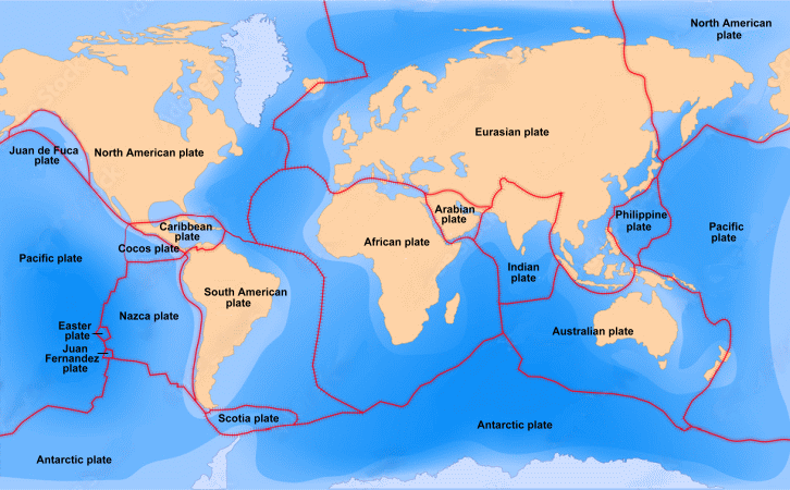 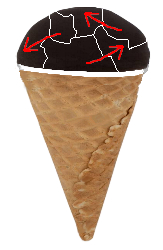 Here's an easy way to visualize what's happening, and it's almost to scale!
Imagine you have an ice cream cone that's been dipped in chocolate. The chocolate forms a thin crust on the surface of the ice cream. If you poke it, it will crack into a number of thin pieces. These can be moved around with your fingers. These segments of chocolate floating on the ice cream represent the crust of the earth, with plates that float on the asthenosphere and can move around. Each plate of crust might contain continents, oceans, or both. The collision of the Indian subcontinent and Eurasion plate (see the map above) created the Himalayan mountain range, home to the world's highest mountain peaks, including thirty that exceed 7300 meters. Because continental drift is still pushing India into Asia, the Himalayas are still growing. When two tectonic plates converge, huge frictional forces build up with time until at a critical point rupturing occurs, producing a fault and an earthquake. Earthquakes within the ocean basins produce tsunamis, but those on the continents release energy in waves. The largest earthquakes are often along the collision zone of two continental plates, particularly around the edges of the Pacific Plate. A well-known fault is the San Andreas Fault of the western USA. When seismic waves are generated by an earthquake, they spread out spherically, but become distorted by underground regions of different density or properties. Faster P-waves are the first to arrive at recording stations, followed by slower S-waves. P waves are compression waves, vibrating the rock forwards and backwards in the direction of propagation. P waves travel fastest and are the first to arrive from the earthquake. S or shear waves cause the rock to oscillate sideways back and forth, perpendicular to the direction of wave propagation. The time delays between P- and S-wave arrivals help determine where the earthquake originated. It takes several such seismic stations to determine the location and size of an earthquake accurately. 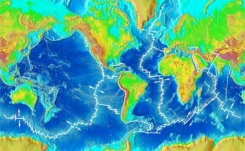 Maps of the ocean floor show a massive undersea mountain range that almost circles the entire Earth. These ridges are the result of molten rock rising from the asthenosphere. As it comes to the undersea floor, it cools, making new crust and spreading the seafloor away from the ridge in a sort of conveyer-belt motion.
After millions of years, crust disappears into ocean trenches at places called subduction zones, and cycle back into the Earth. Evidence for plate tectonics
|