|
When an earthquake occurs somewhere under the surface of the earth, often because of the movement of tectonic plates, shock waves are sent off in all directions. Some of these waves compress the rock layers inside the earth, and this compression wave, or 'P' wave, travels through the earth, eventually to be recorded by your instruments. Other waves from the earthquake travel around the surface of the earth. These waves move up and down just like waves on water, and are called transverse, or 'S' waves. They're the ones that cause damage to things on the surface. Eventually these waves get to you too. 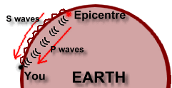 But the 'P' waves move a lot faster. So your measuring device, called a seismograph, will first record the 'P' waves from the earthquake, since they arrive first. Later, when the 'S' waves arrive, it will record those too. 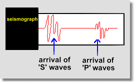 Here's the catch. The farther away the earthquake is from you, the longer the waves will have been travelling. Since the 'P' waves are faster, they will get ahead of the 'S' waves ... and the longer they travel, the farther ahead they will get. This time lag between the arrival of the 'P' waves and the arrival of the 'S' waves will tell you how far away the earthquake was. 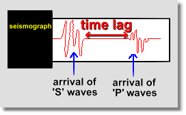 Scientists know how fast each type of wave can move. So the length of this time lag will tell you exactly how far the waves had to travel. You will know how far away from you the earthquake is. But you have no idea from which direction the waves have come! All you know is that the earthquake is (let's suppose) 500 km from you. That means it could have happened anywhere on a circle, on a map, of radius 500 km. If the blue dot represents you, the earthquake occurred somewhere on the circle. 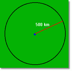 So now what!? All by yourself, that's all you can know. BUT ... suppose another scientist somewhere else ALSO detected the earthquake. At that location, the time delay between the arrival of the two types of waves put the earthquake 300 km. So that scientist knows the earthquake happened 300 km away. By combining his information with yours, you get a map like this: 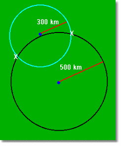 The eathquake must be 500 km from you, and 300 km from the second scientist. That means it must have occurred at one of the two points marked on the map with X's! How can we pinpoint which location was the correct one? Well, we need one more person somewhere to have recorded the arrival of the earthquake waves, and measured the distance. Suppose a third scientist has done this, and discovered that the earthquake was 400 km away from his location. Somewhere on a circle of radius 400 km from him. Let's combine this with the information already on the map: 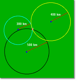 And there we have it! The earthquake location has been pinpointed exactly, at the X where all three circles meet. This has been possible simply because we know how fast the different types of waves move through rock, and because we're able to record these waves. The rest is simple geometry! |